Our website is made possible by displaying online advertisements to our visitors.
Please consider supporting us by disabling your ad blocker.
Downburst


| Part of a series on |
| Weather |
|---|
|
|
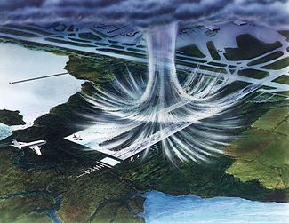
In meteorology, a downburst is a strong downward and outward gushing wind system that emanates from a point source above and blows radially, that is, in straight lines in all directions from the area of impact at surface level. It originates under deep, moist convective conditions like cumulus congestus or cumulonimbus. Capable of producing damaging winds, it may sometimes be confused with a tornado, where high-velocity winds circle a central area, and air moves inward and upward. These usually last for seconds to minutes. Downbursts are particularly strong downdrafts within thunderstorms (or deep, moist convection as sometimes downbursts emanate from cumulonimbus or even cumulus congestus clouds that are not producing lightning). Downbursts are most often created by an area of significantly precipitation-cooled air that, after reaching the surface (subsiding), spreads out in all directions producing strong winds.
Dry downbursts are associated with thunderstorms that exhibit very little rain, while wet downbursts are created by thunderstorms with significant amounts of precipitation.[1] Microbursts and macrobursts are downbursts at very small and larger scales, respectively. A rare variety of dry downburst, the heat burst, is created by vertical currents on the backside of old outflow boundaries and squall lines where rainfall is lacking. Heat bursts generate significantly higher temperatures due to the lack of rain-cooled air in their formation and compressional heating during descent.
Downbursts are a topic of notable discussion in aviation, since they create vertical wind shear, which has the potential to be dangerous to aviation, especially during landing (or takeoff), where airspeed performance windows are the most narrow. Several fatal and historic crashes in past decades are attributed to the phenomenon and flight crew training goes to great lengths on how to properly recognize and recover from a downburst/wind shear event; wind shear recovery, among other adverse weather events, are standard topics across the world in flight simulator training that flight crews receive and must successfully complete. Detection and nowcasting technology was also implemented in much of the world and particularly around major airports, which in many cases actually have wind shear detection equipment on the field. This detection equipment helps air traffic controllers and pilots make decisions on the safety and feasibility of operating on or in the vicinity of the airport during storms.[2]
- ^ US Department of Commerce, NOAA. "Downbursts". www.weather.gov. Retrieved 15 June 2022.
- ^ "Downbursts". PennState. Retrieved 15 June 2022.
Previous Page Next Page


