Our website is made possible by displaying online advertisements to our visitors.
Please consider supporting us by disabling your ad blocker.
Dutch Harbor
Dutch Harbor | |
|---|---|
Harbor | |
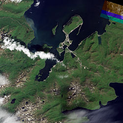
 Natural-color image of Dutch Harbor | |
| Coordinates: 53°54′10.5″N 166°31′06.2″W / 53.902917°N 166.518389°W | |
| Country | United States |
| City | Unalaska, Alaska |
| Time zone | UTC-9 (Alaska (AKST)) |
| • Summer (DST) | UTC-8 (AKDT) |
| ZIP code | 99692[1] |
| Area code | 907 |
Dutch Harbor is a harbor on Amaknak Island in Unalaska, Alaska. It was the location of the Battle of Dutch Harbor in June, 1942 when the Imperial Japanese Navy attacked it just seven months after the attack on Pearl Harbor in Hawaii. To this day, it remains one of the few sites in the United States to be subjected to an aerial bombardment by a foreign power.
Dutch Harbor is now the home of an important fishing industry.[2]
- ^ "Dutch Harbor ZIP Code". zipdatamaps.com. 2022. Retrieved November 11, 2022.
- ^ "Unalaska - About Unalaska". Archived from the original on 2012-10-02. Retrieved 2012-10-14.
Previous Page Next Page


