Our website is made possible by displaying online advertisements to our visitors.
Please consider supporting us by disabling your ad blocker.
El Sereno, Los Angeles
El Sereno | |
|---|---|
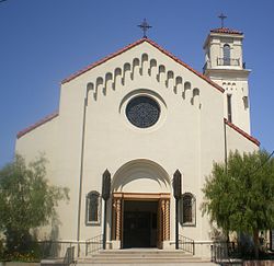
 All Saints Catholic Church | |
| Coordinates: 34°04′52″N 118°10′37″W / 34.08111°N 118.17694°W | |
| Country | United States |
| State | California |
| County | Los Angeles |
| City | Los Angeles |
| Government | |
| • City Council | Kevin de León |
| • State Assembly | Wendy Carrillo (D) |
| • State Senate | Maria Elena Durazo (D) |
| • U.S. House | Jimmy Gomez (D) |
| Area <[1] | |
• Total | 4.1 sq mi (11 km2) |
| Population (2000)[1] | |
• Total | 43,766 |
| • Density | 9,826/sq mi (3,794/km2) |
| Time zone | UTC-8 (PST) |
| • Summer (DST) | UTC-7 (PDT) |
| ZIP code | 90032, 90063 |
| Area code | 323 |
| Website | El Sereno Historical Society[2] |
El Sereno (Spanish, "The Serene One") is a Los Angeles neighborhood in the Eastside Los Angeles region of Los Angeles County, California.

- ^ a b Cite error: The named reference
MappingLAElSerenoProfilewas invoked but never defined (see the help page). - ^ "El Sereno Historical Society".
Previous Page Next Page


