Our website is made possible by displaying online advertisements to our visitors.
Please consider supporting us by disabling your ad blocker.
Electoral district of Gregory
| Gregory Queensland—Legislative Assembly | |||||||||||||||
|---|---|---|---|---|---|---|---|---|---|---|---|---|---|---|---|
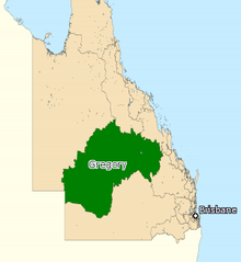
 Map of the electoral district of Gregory, 2017 | |||||||||||||||
| State | Queensland | ||||||||||||||
| Created | 1878 | ||||||||||||||
| MP | Sean Dillon | ||||||||||||||
| Party | Liberal National | ||||||||||||||
| Namesake | Augustus Charles Gregory | ||||||||||||||
| Electors | 24,785 (2020) | ||||||||||||||
| Area | 459,681 km2 (177,483.8 sq mi) | ||||||||||||||
| Demographic | Rural and remote | ||||||||||||||
| Coordinates | 24°39′S 145°22′E / 24.650°S 145.367°E | ||||||||||||||
| |||||||||||||||

Gregory is a Legislative Assembly of Queensland electoral district in Queensland, Australia.[1]
- ^ "Representatives of Queensland State Electorates 1860-2017" (PDF). Queensland Parliamentary Record 2012-2017: The 55th Parliament. Queensland Parliament. Archived from the original (PDF) on 27 April 2020.
Previous Page Next Page


