Our website is made possible by displaying online advertisements to our visitors.
Please consider supporting us by disabling your ad blocker.
Electoral district of South Melbourne
| South Melbourne Victoria—Legislative Assembly | |
|---|---|
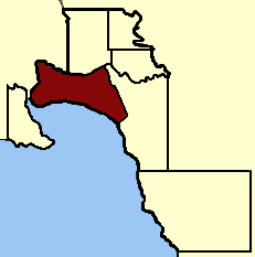
 Location in Victoria | |
| State | Victoria |
| Created | 1856 |
| Abolished | 1859 |
| Demographic | Metropolitan |
Electoral district of South Melbourne was an electoral district of the Legislative Assembly[1] in the British colony of Victoria (Australia).

Its area was defined by the Victoria Constitution Act as: "Bounded on the North by the Yarra Yarra River, from its Junction with the Saltwater River to Princes’ Bridge, on the East by the Road bearing Southeast to the Northern Angle of Section No. 46, St. Kilda, thence by Fitz Roy Street to the Sea Coast, thence by the Sea Coast to the Yarra Yarra River, and by the said River to its Junction with the Saltwater River, being the commencing Point."[2]
South Melbourne was abolished by the Victorian Electoral Act, 1858.[3] New districts of Emerald Hill and Sandridge were created.[3]
- ^ "Re-Member (Former Members)". State Government of Victoria. Retrieved 15 June 2013.
- ^ "Victoria Constitution Act 1855" (PDF). Retrieved 5 May 2013.
- ^ a b "An Act to alter the Electoral Districts of Victoria and to increase the number of Members of the Legislative Assembly thereof" (PDF). 1858. Retrieved 15 June 2013.
Previous Page Next Page


