Our website is made possible by displaying online advertisements to our visitors.
Please consider supporting us by disabling your ad blocker.
Fitzroy, Victoria
| Fitzroy Melbourne, Victoria | |||||||||||||||
|---|---|---|---|---|---|---|---|---|---|---|---|---|---|---|---|
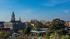
 The Fitzroy skyline, with the Fitzroy Town Hall visible on the far left | |||||||||||||||
 Fitzroy Town Hall | |||||||||||||||
 | |||||||||||||||
| Coordinates | 37°47′54″S 144°58′43″E / 37.7984°S 144.9785°E | ||||||||||||||
| Population | 10,431 (SAL 2021)[1] | ||||||||||||||
| Established | 1839 | ||||||||||||||
| Postcode(s) | 3065 | ||||||||||||||
| Elevation | 35 m (115 ft) | ||||||||||||||
| Area | 1.4 km2 (0.5 sq mi) | ||||||||||||||
| Location | 3 km (2 mi) from Melbourne CBD | ||||||||||||||
| LGA(s) | City of Yarra | ||||||||||||||
| State electorate(s) | Richmond | ||||||||||||||
| Federal division(s) | Melbourne | ||||||||||||||
| |||||||||||||||
Fitzroy is an inner-city suburb in Melbourne, Victoria, Australia, 3 km (1.9 mi) north-east of the Melbourne central business district, located within the City of Yarra local government area. Fitzroy recorded a population of 10,431 at the 2021 census.[2]
Planned as Melbourne's first suburb in 1839,[3] it later became one of the city's first areas to gain municipal status, in 1858, then known as Fitz Roy.[4] It occupies Melbourne's smallest and most densely populated area outside the CBD, just 100 ha.
Fitzroy is known as a cultural hub, particularly for its live music scene and street art, and is the main home of the Melbourne Fringe Festival. Its commercial heart is Brunswick Street, one of Melbourne's major retail, culinary, and nightlife strips. Long associated with the working class, Fitzroy has undergone waves of urban renewal and gentrification since the 1980s and today is home to a wide variety of socio-economic groups, featuring both some of the most expensive rents in Melbourne and one of its largest public housing complexes, Atherton Gardens.
Its built environment is diverse and features some of the finest examples of Victorian era architecture in Melbourne. Much of the suburb is a historic preservation precinct, with many individual buildings and streetscapes covered by Heritage Overlays.[5] The most recent changes to Fitzroy are mandated by the Melbourne 2030 Metropolitan Strategy, in which both Brunswick Street and nearby Smith Street are designated for redevelopment as Activity centres.
The suburb was named after Sir Charles Augustus FitzRoy, the Governor of New South Wales from 1846 to 1855.[6] It is bordered by Alexandra Parade (north), Victoria Parade (south), Smith Street (east) and Nicholson Street.
- ^ Australian Bureau of Statistics (28 June 2022). "Fitzroy (Vic.) (suburb and locality)". Australian Census 2021 QuickStats. Retrieved 28 June 2022.
- ^ Australian Bureau of Statistics (28 June 2022). "Fitzroy (Vic.) (Suburbs and Localities)". 2021 Census QuickStats. Retrieved 18 July 2022.
- ^ "Fitzroy, Victoria". 2 July 2004. Archived from the original on 2 July 2004. Retrieved 26 August 2018.
- ^ "Municipal Government". eMelbourne – The Encyclopedia of Melbourne Online. School of Historical Studies, Department of History, The University of Melbourne. Retrieved 30 April 2018.
- ^ "??". Department of Environment, Land, Water & Planning. 22 May 2017. Retrieved 26 August 2018.
- ^ First, Jamie (7 January 2014). "The A–Z story of our suburbs". Herald Sun. Retrieved 27 October 2017.
Previous Page Next Page


