Our website is made possible by displaying online advertisements to our visitors.
Please consider supporting us by disabling your ad blocker.
Fort Stockton, Texas
Fort Stockton, Texas | |
|---|---|
 Historical places in Fort Stockton | |
| Nickname(s): "Stockton; Stakitas" | |
| Motto: The Heart of Pecos County | |
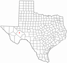
 Location of Fort Stockton, Texas | |
 | |
| Coordinates: 30°53′29″N 102°53′6″W / 30.89139°N 102.88500°W[1] | |
| Country | United States |
| State | Texas |
| County | Pecos |
| Government | |
| • Mayor | Paul Casias |
| Area | |
• Total | 5.55 sq mi (14.37 km2) |
| • Land | 5.55 sq mi (14.37 km2) |
| • Water | 0.00 sq mi (0.00 km2) |
| Elevation | 2,972 ft (906 m) |
| Population (2020) | |
• Total | 8,466 |
| • Density | 1,422.3/sq mi (549.14/km2) |
| Time zone | UTC-6 (Central (CST)) |
| • Summer (DST) | UTC-5 (CDT) |
| ZIP code | 79735 |
| Area code | 432 |
| FIPS code | 48-26808[3] |
| GNIS feature ID | 1357597[4] |
| Website | cityoffortstockton |
Fort Stockton is a city in and the county seat of Pecos County, Texas, United States. It is located on Interstate 10, future Interstate 14, U.S. Highways 67, 285, and 385, and the Santa Fe Railroad, 329 mi (529 km) northwest of San Antonio and 240 mi (390 km) southeast of El Paso. Its population was 8,466 at the 2020 census.[5]
- ^ "US Gazetteer files: 2010, 2000, and 1990". United States Census Bureau. February 12, 2011. Retrieved April 23, 2011.
- ^ "2019 U.S. Gazetteer Files". United States Census Bureau. Retrieved August 7, 2020.
- ^ "U.S. Census website". United States Census Bureau. Retrieved January 31, 2008.
- ^ "US Board on Geographic Names". United States Geological Survey. October 25, 2007. Retrieved January 31, 2008.
- ^ [data.census.gov "2020 Census"]. data.census.gov. Retrieved November 10, 2023.
{{cite web}}: Check|url=value (help)
Previous Page Next Page


