Our website is made possible by displaying online advertisements to our visitors.
Please consider supporting us by disabling your ad blocker.
Fort Ticonderoga
Fort Ticonderoga | |
Fort Ticonderoga from Mount Defiance | |
| Location | Ticonderoga, New York |
|---|---|
| Nearest city | Burlington, Vermont |
| Coordinates | 43°50′30″N 73°23′15″W / 43.84167°N 73.38750°W |
| Area | 21,950 acres (34.3 sq mi; 88.8 km2) |
| Built | 1755–1758 |
| Architect | Marquis de Lotbinière |
| Architectural style | Vauban-style fortress |
| NRHP reference No. | 66000519 |
| Significant dates | |
| Added to NRHP | October 15, 1966[1] |
| Designated NHL | October 9, 1960[2] |

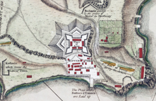
Fort Ticonderoga (/taɪkɒndəˈroʊɡə/), formerly Fort Carillon, is a large 18th-century star fort built by the French at a narrows near the south end of Lake Champlain in northern New York. It was constructed between October 1755 and 1757 by French-Canadian military engineer Michel Chartier de Lotbinière, Marquis de Lotbinière during the action in the "North American theater" of the Seven Years' War, known as the French and Indian War in America. The fort was of strategic importance during the 18th-century colonial conflicts between Great Britain and France, and again played an important role during the American Revolutionary War.
The site controlled a river portage alongside the mouth of the rapids-infested La Chute River, in the 3.5 miles (5.6 km) between Lake Champlain and Lake George. It was strategically placed for the trade routes between the British-controlled Hudson River Valley and the French-controlled Saint Lawrence River Valley.
The terrain amplified the importance of the site. Both lakes were long and narrow and oriented north–south, as were the many ridge lines of the Appalachian Mountains which extend as far south as Georgia. The mountains created nearly impassable terrains to the east and west of the Great Appalachian Valley that the site commanded.
The name "Ticonderoga" comes from the Iroquois word tekontaró:ken, meaning "it is at the junction of two waterways".[3]
During the 1758 Battle of Carillon, 4,000 French defenders were able to repel an attack by 16,000 British troops near the fort. In 1759, the British returned and drove a token French garrison from the fort. The British controlled the fort at the beginning of the Revolutionary War, but the Green Mountain Boys and other state militia under the command of Ethan Allen and Benedict Arnold captured it on May 10, 1775. Henry Knox led a party to transport many of the fort's cannon to Boston to assist in the siege against the British, who evacuated the city in March 1776. The Americans held the fort until June 1777, when British forces under General John Burgoyne occupied high ground above it; the threat resulted in the Continental Army troops withdrawing from the fort and its surrounding defenses. The only direct attack on the fort during the Revolution took place in September 1777, when John Brown led 500 Americans in an unsuccessful attempt to capture it from about 100 British defenders.
The British abandoned the fort after the failure of the Saratoga campaign, and it ceased to be of military value after 1781. The United States allowed the fort to fall into ruin, and local residents stripped it of much of its usable materials. It was purchased by a private family in 1820 and became a stop on tourist routes of the area. Early in the 20th century, its private owners restored the fort. The Fort Ticonderoga Association now operates it as a tourist attraction, museum, and research center.
Previous Page Next Page


