Our website is made possible by displaying online advertisements to our visitors.
Please consider supporting us by disabling your ad blocker.
Foveaux Strait
| Foveaux Strait | |
|---|---|
| Te Ara-a-Kiwa (Māori) | |
 | |
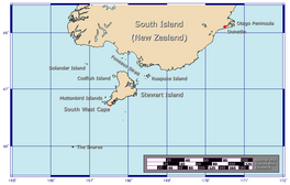
Foveaux Strait separates the South and Stewart Island islands of New Zealand. | |
| Coordinates | 46°40′S 168°11′E / 46.67°S 168.18°E |
| Surface area | 2,460 square kilometres (950 sq mi) |
Foveaux Strait (/foʊvoʊ/ FOH-voh; Māori: Te Ara-a-Kiwa, lit. 'the Path of Kiwa') is a strait that separates Stewart Island from the South Island of New Zealand. The width of the strait ranges from about 23 to 53 km (14 to 33 mi), and the depth varies between 18 and 46 m (59 and 151 ft). The strait was first charted by an American sealer, Owen Folger Smith. He charted the strait from a whaleboat of the sealing brig Union in 1804.
The passage was named Foveaux Strait in March 1809, after Joseph Foveaux, the Lieutenant-Governor of New South Wales in Australia. Ferry services across Foveaux Strait began in 1877 and continue to operate regularly between Bluff Harbour and Oban. The strait has been described as "one of the roughest and most unpredictable stretches of water in the world". Severe weather and sea conditions in the strait have contributed to multiple shipwrecks and fatalities. One of these losses was the wreck of the SS Tararua in 1881—the worst maritime disaster for civilian vessels in New Zealand's history, with 131 fatalities. There are currently no formal definitions of the eastern and western boundaries of the strait.
The waters of Foveaux Strait are the main location in New Zealand for dredging for Bluff oysters. There are a large number of small islands in the strait, including Ruapuke Island and the northern Muttonbird Islands. These islands are locations for muttonbirding—the harvest by Rakiura Māori of sooty shearwater (or tītī) chicks. New Zealand fur seals in the region were hunted in major seal hunting operations in the early 1800s until populations were severely depleted, and whaling was a major industry over the 40-year period from 1844 to 1885.
Foveaux Strait is known for its biodiversity, particularly seabirds and marine mammals. The region has significant populations of seven species of globally threatened seabirds, including yellow-eyed penguins. Multiple areas of coastline, islands and open sea within the strait have been recognised as Important Bird and Biodiversity Areas. Some marine mammals are resident in the strait throughout the year, while others, such as baleen whales, pass through in winter and spring on migration. The wider region also has small populations of nationally endangered dolphins, including Hector's dolphin. The Catlins Coast Marine Mammal Sanctuary lies mostly within the strait.
Previous Page Next Page


