Our website is made possible by displaying online advertisements to our visitors.
Please consider supporting us by disabling your ad blocker.
Frameries
You can help expand this article with text translated from the corresponding article in French. (August 2016) Click [show] for important translation instructions.
|
Frameries
Framrie (Picard) | |
|---|---|
 Church Square and the big sundial | |
| Coordinates: 50°24′N 03°54′E / 50.400°N 3.900°E | |
| Country | |
| Community | French Community |
| Region | Wallonia |
| Province | Hainaut |
| Arrondissement | Mons |
| Government | |
| • Mayor | Jean-Marc Dupont (PS) |
| • Governing party/ies | Coalition PS-MR |
| Area | |
• Total | 26.09 km2 (10.07 sq mi) |
| Population (2018-01-01)[1] | |
• Total | 21,878 |
| • Density | 840/km2 (2,200/sq mi) |
| Postal codes | 7080 |
| NIS code | 53028 |
| Area codes | 065 |
| Website | www.frameries.be |
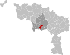
Frameries (French pronunciation: [fʁam(ə)ʁi]; Picard: Framrie; Walloon: Framriye) is a municipality of Wallonia located in the province of Hainaut, Belgium.
The municipality consists of the following districts: Eugies, Frameries, La Bouverie, Noirchain, and Sars-la-Bruyère.
- ^ "Wettelijke Bevolking per gemeente op 1 januari 2018". Statbel. Retrieved 9 March 2019.
Previous Page Next Page


