Our website is made possible by displaying online advertisements to our visitors.
Please consider supporting us by disabling your ad blocker.
Frankfort, Kentucky
Frankfort | |
|---|---|
Historic District, downtown Church of the Good Shepherd Downtown at night Frankfort in 2009 | |
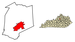
 Location of Frankfort in Franklin County, Kentucky | |
| Coordinates: 38°12′N 84°52′W / 38.200°N 84.867°W | |
| Country | United States |
| State | Kentucky |
| County | Franklin |
| Established | 1786 |
| Incorporated | February 28, 1835 |
| Government | |
| • Type | Commission/Manager |
| • Mayor | Layne Wilkerson[1] |
| Area | |
• Total | 15.07 sq mi (39.03 km2) |
| • Land | 14.77 sq mi (38.25 km2) |
| • Water | 0.30 sq mi (0.78 km2) |
| Elevation | 505 ft (154 m) |
| Population (2020) | |
• Total | 28,602 |
• Estimate (2022)[4] | 28,391 |
| • Density | 1,900/sq mi (730/km2) |
| Time zone | UTC−05:00 (EST) |
| • Summer (DST) | UTC−04:00 (EDT) |
| ZIP Code | 40601-40604, 40618-40622 |
| Area code | 502 |
| FIPS code | 21-28900 |
| GNIS feature ID | 517517[3] |
| Website | City website |
Frankfort is the capital of the U.S. state of Kentucky and the seat of Franklin County.[5] It is a home rule-class city.[6] The population was 28,602 at the 2020 United States census.[7] Located along the Kentucky River, Frankfort is the principal city of the Frankfort, Kentucky Micropolitan Statistical Area, which includes all of Franklin and Anderson counties.
Before Frankfort was founded, the site was a ford across the Kentucky River, along one of the great buffalo trails used as highways in colonial America.[8] English explorers first visited the area in the 1750s. The site evidently received its name after an incident in 1780, when pioneer Stephen Frank was killed in a skirmish with Native Americans; the crossing was named "Frank's Ford" in his memory.[8] In 1786, the Virginia legislature designated 100 acres (40 hectares) as the town of Frankfort and, after Kentucky became a state in 1792, it was chosen as capital.[8][9]
The city is located in the inner Bluegrass region of Kentucky.[10] The Kentucky River flows through the city, making a turn as it passes through the center of town; the Downtown and South Frankfort districts are opposite one another on each side of the river. The suburban areas on either side of the river valley are known as East and West Frankfort. Frankfort has four distinct seasons; winter is normally cool with some snowfall, while summers are hot and humid.[11][12]
Because of the city's location on the Kentucky River, it has flooded many times, with the two highest recorded floods occurring in 1937 and 1978.[10] The North Frankfort levee, finished in 1969, and the South Frankfort floodwall, built in the 1990s, were constructed for flood protection.[10] Five bridges cross the river in downtown Frankfort, including the St. Clair Street bridge and Capitol Avenue bridge.[10] Notable locations include the Kentucky State Capitol building, the Capital City Museum,[13] and Fort Hill, a promontory with a view of downtown.
As of 2016, the city's largest industry was public administration with 28% of the workforce.[14] Manufacturing totaled over 12% of the workforce.[14] Frankfort is adjacent to Interstate 64, and Interstate 75 is nearby; general aviation access is via the Capital City Airport, and commercial air travel is available through Blue Grass Airport in Lexington.[14]
- ^ "Mayor Layne Wilkerson". City of Frankfort, Kentucky. Retrieved January 12, 2022.
- ^ "2020 U.S. Gazetteer Files". United States Census Bureau. Retrieved March 18, 2022.
- ^ a b U.S. Geological Survey Geographic Names Information System: Frankfort, Kentucky
- ^ "Annual Estimates of the Resident Population for Incorporated Places in Kentucky: April 1, 2020 to July 1, 2022". United States Census Bureau. Retrieved May 26, 2023.
- ^ "Find a County". National Association of Counties. Archived from the original on May 31, 2011. Retrieved June 7, 2011.
- ^ "Summary and Reference Guide to House Bill 331 City Classification Reform" (PDF). Kentucky League of Cities. Archived (PDF) from the original on November 11, 2014. Retrieved December 30, 2014.
- ^ Cite error: The named reference
QF2020was invoked but never defined (see the help page). - ^ a b c "City History". Official website. City of Frankfort, Kentucky. Archived from the original on July 18, 2016. Retrieved July 1, 2016.
- ^ "Kentucky Historical Marker 1774" Archived August 18, 2006, at the Wayback Machine. Kentucky Historical Society Website
- ^ a b c d "Geography | Frankfort, KY". www.frankfort.ky.gov. Archived from the original on June 11, 2023. Retrieved June 11, 2023.
- ^ "Station: Frankfort Lock 4, KY". U.S. Monthly Climate Normals (1981-2010). National Oceanic and Atmospheric Administration. Retrieved June 4, 2021.
- ^ "Monthly Highest Max Temperature and Monthly Lowest Min Temperature for Frankfort Downtown, KY". Applied Climate Information System. Retrieved June 4, 2021.
- ^ Cite error: The named reference
:4was invoked but never defined (see the help page). - ^ a b c "Economy | Frankfort, KY". www.frankfort.ky.gov. Retrieved June 11, 2023.
Previous Page Next Page


