Our website is made possible by displaying online advertisements to our visitors.
Please consider supporting us by disabling your ad blocker.
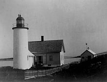
Franklin Island Light
 | |
 | |
| Location | Muscongus Bay, Maine |
|---|---|
| Coordinates | 43°53′31.4″N 69°22′28.6″W / 43.892056°N 69.374611°W |
| Tower | |
| Constructed | 1805 |
| Automated | 1967 |
| Height | 45 feet (14 m) |
| Shape | Cylindrical Brick Tower |
| Markings | White |
| Light | |
| First lit | 1855 (current structure) |
| Focal height | 57 feet (17 m) |
| Lens | 4th degree Fresnel lens (original), 9.8 inches (250 mm) (current) |
| Range | 8 nautical miles (15 km; 9.2 mi) |
| Characteristic | Fl W 6s |
Franklin Island Light is a lighthouse on Franklin Island, in Muscongus Bay, Maine, USA.[1][2][3] It was first established in 1805. The present structure was built in 1855.
- ^ "Historic Light Station Information and Photography: Maine". United States Coast Guard Historian's Office. 2009-08-06. Archived from the original on 2017-05-01.
- ^ Light List, Volume I, Atlantic Coast, St. Croix River, Maine to Shrewsbury River, New Jersey (PDF). Light List. United States Coast Guard. 2009. p. 44.
- ^ Rowlett, Russ (2009-10-09). "Lighthouses of the United States: Southern Maine". The Lighthouse Directory. University of North Carolina at Chapel Hill.
Previous Page Next Page


