Our website is made possible by displaying online advertisements to our visitors.
Please consider supporting us by disabling your ad blocker.
Fuga Island
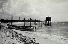
 Fuga Island tide gauge in 1927 | |
| Geography | |
|---|---|
| Coordinates | 18°52′21″N 121°22′44″E / 18.87250°N 121.37889°E |
| Archipelago | Babuyan Islands |
| Adjacent to | Babuyan Channel |
| Area | 97.1 km2 (37.5 sq mi)[1] |
| Highest elevation | 191 m (627 ft)[2] |
| Highest point | Mount Nanguringan |
| Administration | |
| Region | Cagayan Valley |
| Province | Cagayan |
| Municipality | Aparri |
| Demographics | |
| Population | 1,939 (2020)[3] |
| Pop. density | 20/km2 (50/sq mi) |
| Additional information | |
 | |
Fuga Island is an island and barangay located north of Luzon and is part of the Babuyan Islands, which is the second-northernmost island group of the Philippines. Barangay Fuga Island is one of the 42 barangays under the jurisdiction of the municipality of Aparri in the province of Cagayan.
- ^ Genevieve Broad; Carl Oliveros. "Biodiversity and conservation priority setting in the Babuyan Islands, Philippines" (PDF). The Technical Journal of Philippine Ecosystems and Natural Resources. 15 (1–2): 1–30. Retrieved 18 April 2018.
- ^ Cite error: The named reference
mapwas invoked but never defined (see the help page). - ^ Census of Population (2020). "Region II (Cagayan Valley)". Total Population by Province, City, Municipality and Barangay. Philippine Statistics Authority. Retrieved 8 July 2021.
Previous Page Next Page


