Our website is made possible by displaying online advertisements to our visitors.
Please consider supporting us by disabling your ad blocker.
Gail (river)
| Gail | |
|---|---|
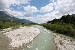
 Gail River near Dellach | |
 | |
| Location | |
| Country | Austria |
| Physical characteristics | |
| Source | |
| • location | Obertilliach, East Tyrol |
| Mouth | |
• location | Drava River near Villach |
• coordinates | 46°36′23″N 13°53′14″E / 46.60639°N 13.88722°E |
| Length | 121.9 km (75.7 mi)[1] |
| Basin size | 1,413.9 km2 (545.9 sq mi)[2] |
| Discharge | |
| • average | 45.08 m3 (1,592 cu ft) |
| Basin features | |
| Progression | Drava→ Danube→ Black Sea |
Gail (Slovene: Zilja, Italian: Zeglia) is the name of a river in southern Austria, the largest right tributary of the Drava. Its drainage basin is 1,413.9 km2 (545.9 sq mi).[2]
- ^ TIRIS Geographical information system of Tyrol
- ^ a b "Flächenverzeichnis der Flussgebiete: Draugebiet" (PDF). Beiträge zur Hydrografie Österreichs Heft 59. October 2011. p. 64.
Previous Page Next Page


