Our website is made possible by displaying online advertisements to our visitors.
Please consider supporting us by disabling your ad blocker.
Garabit viaduct
Garabit Viaduct Viaduc de Garabit | |
|---|---|
 | |
| Coordinates | 44°58′31″N 3°10′39″E / 44.97528°N 3.17750°E |
| Carries | Railway |
| Crosses | Truyère river |
| Characteristics | |
| Material | Wrought iron |
| Total length | 565 metres (1,854 ft) |
| Width | 6 metres (20 ft) |
| Height | 124 metres (407 ft) |
| Longest span | 165 metres (541 ft) |
| History | |
| Architect | Gustave Eiffel |
| Construction start | 1882 |
| Construction end | 1884 |
| Construction cost | 3,100,000 francs |
| Opened | 1885 |
| Location | |
 | |
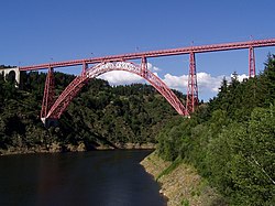
The Garabit viaduct (French: viaduc de Garabit) is a railway arch bridge spanning the Truyère, near Ruynes-en-Margeride, Cantal, France, in the mountainous Massif Central region.
The bridge was constructed between 1882 and 1884 by Gustave Eiffel, with structural engineering by Maurice Koechlin,[1] and was opened in 1885. It is 565 m (1,854 ft) in length and has a principal arch of 165 m (541 ft) span.[2]
- ^ Loyrette (1985), p. 77.
- ^ Loyrette (1985), p. 81.
Previous Page Next Page


