Our website is made possible by displaying online advertisements to our visitors.
Please consider supporting us by disabling your ad blocker.
Geography of Bhutan
| ||
| Continent | Asia | |
| Subregion | South Asia | |
| Geographic coordinates | 27°30′N 90°30′E / 27.500°N 90.500°E | |
| Area - Total - Water |
Ranked 137th 38,394 km2 (14,824.0 sq mi) 0 km2 (0 sq mi) (landlocked) | |
| Coastline | 0 km (0 mi) | |
| Land boundaries | 1,136 km (706 mi) | |
| Countries bordered | China 477 km (296 mi), India 659 km (409 mi) | |
| Highest point | Gangkhar Puensum, 7,570 m (24,836 ft) [1] | |
| Lowest point | Drangme Chhu, 97 m (318 ft) [1] | |
| Longest river | ||
| Largest inland body of water | ||
| Land Use - Arable land - Permanent crops - Other |
2.62% 0.34% 97.27% (2012 est.) | |
| Irrigated Land | 319.1 km2 (123.2 sq mi) (2010) | |
| Climate: | Varies; tropical in southern plains; cool winters and hot summers in central valleys; severe winters and cool summers in Himalayas | |
| Natural resources | timber, hydropower, gypsum, calcium carbonate | |
| Natural hazards | Violent storms from the Himalayas are the source of the country's name, which translates as Land of the Thunder Dragon; frequent landslides during the rainy season | |
| Environmental issues | soil erosion; limited access to potable water | |

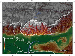
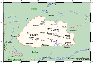
Bhutan is a sovereign country at the crossroads of East Asia and South Asia, located towards the eastern extreme of the Himalayas mountain range. It is fairly evenly sandwiched between the sovereign territory of two nations: first, the People's Republic of China (PRC) on the north and northwest. There are approximately 477 kilometres (296 mi) of border with the country's Tibet Autonomous Region (TAR), or simply Tibet. The second nation is the Republic of India on the south, southwest, and east; there are approximately 659 kilometres (409 mi) with the states of Arunachal Pradesh, Assam, West Bengal, and Sikkim, in clockwise order from the kingdom. Bhutan's total borders amount to approximately 1,139 kilometres (708 mi). The Indian state of Sikkim to the west, the India to the south, and the Assam state of India to the southeast are other close neighbours; the former two are separated by only very small stretches of Indian territory.
Bhutan is a very compact landlocked nation, but with just a small bit more length than width. The nation's territory totals an approximate 38,394 square kilometres (14,824 sq mi). Because of its inland, landlocked status, it controls no territorial waters. Bhutan's territory used to extend south into present-day Assam, including the protectorate of Cooch Behar, but, starting from 1772, the British East India Company (EIC) began to push back the borders through a number of wars and treaties, severely reducing Bhutan's size until the Treaty of Sinchula of 1865, when some border land was ceded back. Later, many of these territories were permanently lost to British India under the Treaty of Punakha and today remains a part of modern-day India.
- ^ a b "Bhutan". World Factbook. CIA. 22 March 2011. Retrieved 3 April 2011.
Previous Page Next Page


