Our website is made possible by displaying online advertisements to our visitors.
Please consider supporting us by disabling your ad blocker.
Geography of Mayotte
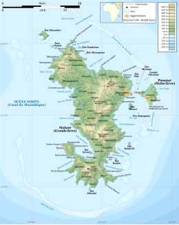
Native name: Mahoré Nickname: Grande-Terre | |
|---|---|
 Map of Mayotte | |
 | |
| Geography | |
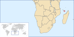
| Location | Mozambique Channel |
| Coordinates | 12°50′S 45°10′E / 12.833°S 45.167°E |
| Archipelago | Comoro Islands |
| Area | 374 km2 (144 sq mi) |
| Length | 39 km (24.2 mi) |
| Width | 22 km (13.7 mi) |
| Coastline | 185.2 km (115.08 mi) |
| Highest elevation | 660 m (2170 ft) |
| Highest point | Benara |
| Administration | |
France | |
| Overseas Department | Mayotte |
| Largest settlement | Mamoudzou (pop. 57,281) |
| Demographics | |
| Population | 256,518 (2017) |
| Pop. density | 690/km2 (1790/sq mi) |
| Ethnic groups | Mahoran |
Mayotte is an island of volcanic origin in the northernmost Mozambique Channel, about one-half of the way from northern Madagascar to northern Mozambique. Mayotte is part of the Comoro Islands, and like them is the result of a former geological hot spot, the oldest of the Comoros archipelago, formed about 7.7 mya.[1] Mayotte has an area of 374 square kilometres, and a coastline of length 185.2 km. Its maritime claims are an exclusive economic zone of 200 nautical miles, and a territorial sea of 12 nm.
- ^ Thomas Schlüter, Martin H. Trauth, Geological Atlas of Africa, s.v. "The Comoros", 2008:74.
Previous Page Next Page


