Our website is made possible by displaying online advertisements to our visitors.
Please consider supporting us by disabling your ad blocker.
Geography of Somalia
 | |
| Region | Horn of Africa |
|---|---|
| Coordinates | 5°35′39″N 47°13′09″E / 5.5941182°N 47.2192383°E |
| Area | Ranked 42nd |
| • Total | 637,657 km2 (246,201 sq mi) |
| Coastline | 3,333 km (2,071 mi) |
| Borders | Total land borders:[1] 60 km (37 mi) 2,340 km (1,450 mi) 1,600 km (990 mi) 682 km (424 mi) |
| Highest point | Shimbiris 2,460 m (8,070.9 ft) |
| Lowest point | Indian Ocean 0 m (0.0 ft) |
| Longest river | Shebelle River 1,130 km (702.1 mi) |
| Exclusive economic zone | 825,052 km2 (318,554 sq mi) |

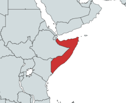
Somalia is a country located in the Horn of Africa which officially consists of the intra-46th meridian east territory, the seven federal member states, namely Galmudug, Hirshabelle, Jubaland, South West, Puntland, and the municipality of Benadir.[2] It is bordered by Ethiopia to the west, the Gulf of Aden to the north, the Somali Sea and Guardafui Channel to the east, and Kenya to the southwest. With a land area of 637,657 square kilometers, Somalia's terrain consists mainly of plateaus, plains and highlands.[3] Its coastline is more than 3,333 kilometers in length, the longest of mainland Africa.[4] It has been described as being roughly shaped "like a tilted number seven".[5]
In the far north, the rugged east–west ranges of the Ogo Mountains lie at varying distances from the Gulf of Aden coast. Hot conditions prevail year-round, along with periodic monsoon winds and irregular rainfall.[6] Geology suggests the presence of valuable mineral deposits.
Somalia is separated from Seychelles by the Somali Sea and is separated from Socotra by the Guardafui Channel.
- ^ "Geography and Map of Somalia". Archived from the original on 12 April 2014. Retrieved 26 January 2014.
- ^ "Federal Member States (FMS)". 13 April 2018. Archived from the original on 18 June 2022. Retrieved 15 March 2020.
- ^ "Somalia". World Factbook. Central Intelligence Agency. 2009-05-14. Archived from the original on June 12, 2007. Retrieved 2009-05-31.
- ^ "Coastline". World Factbook. Central Intelligence Agency. Archived from the original on June 13, 2007. Retrieved 2013-08-03.
- ^ Ganzglass, Martin R. "The Somali Refugees-Africa's Open Wound Refuses to Heal." Hum. Rts. 8 (1979): 28.
- ^ "Somalia – Climate". countrystudies.us. 14 May 2009.
Previous Page Next Page


