Our website is made possible by displaying online advertisements to our visitors.
Please consider supporting us by disabling your ad blocker.
Geography of Western Sahara
This article needs additional citations for verification. (April 2015) |
  | |
| Continent | Africa |
|---|---|
| Region | North Africa |
| Coordinates | 24°30′N 13°00′W / 24.500°N 13.000°W |
| Area | Ranked 78th |
| • Total | 266,000 km2 (103,000 sq mi) |
| Coastline | 1,110 km (690 mi) |
| Borders |
|
| Highest point | unnamed elevation: 701 metres (2,300 ft) |
| Lowest point | Sebjet Tah, −55 metres (−180 ft) [citation needed] |


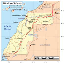
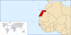
Western Sahara is a territory in Northern Africa, bordered by the North Atlantic Ocean, Morocco proper, Algeria (Tindouf region), and Mauritania. Geographic coordinates: 24°30′N 13°00′W / 24.500°N 13.000°W
Previous Page Next Page
جغرافيا الصحراء الغربية Arabic Xeografía d'El Sáḥara Occidental AST Geografía del Sahara Occidental Spanish Géographie du Sahara occidental French 西サハラの地理 Japanese Geografia Sahary Zachodniej Polish Geografia do Saara Ocidental Portuguese Географія Західної Сахари Ukrainian Giografia del Sahara Ocidentale VEC


