Our website is made possible by displaying online advertisements to our visitors.
Please consider supporting us by disabling your ad blocker.
Geography of the State of Palestine
This article needs additional citations for verification. (December 2018) |


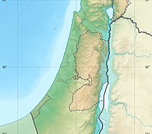
The geography of the State of Palestine refers to the geographic, climatic and other properties of the areas claimed by State of Palestine. Palestine is 163rd largest country in the world, in terms of claimed areas. The country is bordered by Israel to the east, north and west, Jordan to the east, Egypt to the southwest and the Mediterranean Sea to the west. The country also shares maritime borders with Israel, Cyprus and Egypt. Located in the Levant, Palestine is part of the Middle Eastern region in Asia.
Previous Page Next Page
Kategorie:Geografii vo de Palestinensischi Autonomiigebiet ALS جغرافيا فلسطين Arabic Fələstin coğrafiyası AZ Géographie de la Palestine French Geografi Palestin Malay Geografia do Estado da Palestina Portuguese География Палестины Russian Gjeografia e Shtetit të Palestinës SQ Jiografia ya Palestina Swahili Географія Палестини Ukrainian


