Our website is made possible by displaying online advertisements to our visitors.
Please consider supporting us by disabling your ad blocker.
Geology of the Himalayas
This article needs additional citations for verification. (March 2024) |


The geology of the Himalayas is a record of the most dramatic and visible creations of the immense mountain range formed by plate tectonic forces and sculpted by weathering and erosion. The Himalayas, which stretch over 2400 km between the Namcha Barwa syntaxis at the eastern end of the mountain range and the Nanga Parbat syntaxis at the western end, are the result of an ongoing orogeny — the collision of the continental crust of two tectonic plates, namely, the Indian Plate thrusting into the Eurasian Plate. The Himalaya-Tibet region supplies fresh water for more than one-fifth of the world population, and accounts for a quarter of the global sedimentary budget. Topographically, the belt has many superlatives: the highest rate of uplift (nearly 10 mm/year at Nanga Parbat), the highest relief (8848 m at Mt. Everest Chomolangma), among the highest erosion rates at 2–12 mm/yr,[4] the source of some of the greatest rivers and the highest concentration of glaciers outside of the polar regions. This last feature earned the Himalaya its name, originating from the Sanskrit for "the abode of the snow".
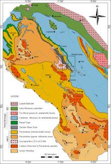
From south to north the Himalaya (Himalaya orogen) is divided into 4 parallel tectonostratigraphic zones and 5 thrust faults which extend across the length of Himalaya orogen. Each zone, flanked by the thrust faults on its north and south, has stratigraphy (type of rocks and their layering) different from the adjacent zones. From south to north, the zones and the major faults separating them are the Main Frontal Thrust (MFT), Subhimalaya Zone (also called Sivalik), Main Boundary Thrust (MBT), Lesser Himalaya (further subdivided into the "Lesser Himalayan Sedimentary Zone (LHSZ) and the Lesser Himalayan Crystalline Nappes (LHCN)), Main Central thrust (MCT), Higher (or Greater) Himalayan crystallines (HHC), South Tibetan detachment system (STD), Tethys Himalaya (TH), and the Indus‐Tsangpo Suture Zone (ISZ).[5] North of this lies the Transhimalaya in Tibet which is outside the Himalayas. The Himalayas border the Indo-Gangetic Plain to the south, Pamir Mountains to the west in Central Asia, and the Hengduan Mountains to the east on the China–Myanmar border.
From east to west the Himalayas are divided into 3 regions, Eastern Himalaya, Central Himalaya, and Western Himalaya, which collectively house several nations and states.
Cite error: There are <ref group=lower-alpha> tags or {{efn}} templates on this page, but the references will not show without a {{reflist|group=lower-alpha}} template or {{notelist}} template (see the help page).
Previous Page Next Page


