Our website is made possible by displaying online advertisements to our visitors.
Please consider supporting us by disabling your ad blocker.
Ghuwayr Abu Shusha
Ghuwayr Abu Shusha
غُويّر أبو شوشة | |
|---|---|
 Maqam Sheikh Abu Shusha | |
| Etymology: from personal name; meaning the “father of” wearing “a top knot”[1] | |
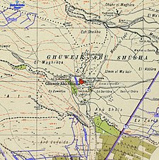
A series of historical maps of the area around Ghuwayr Abu Shusha (click the buttons) | |
Location within Mandatory Palestine | |
| Coordinates: 32°51′13″N 35°30′26″E / 32.85361°N 35.50722°E | |
| Palestine grid | 197/251 |
| Geopolitical entity | Mandatory Palestine |
| Subdistrict | Tiberias |
| Date of depopulation | 21 and 28 April 1948[4] |
| Area | |
• Total | 8,609 dunams (8.609 km2 or 3.324 sq mi) |
| Population (1945) | |
• Total | 1,240[2][3] |
| Cause(s) of depopulation | Military assault by Yishuv forces |
| Secondary cause | Influence of nearby town's fall |
| Current Localities | Ginosar,[5] Livnim[5] |
Ghuwayr Abu Shusha was a Palestinian Arab village in the Tiberias Subdistrict. It was depopulated during the 1947–1948 Civil War in Mandatory Palestine on April 21, 1948. It was located 8 km north of Tiberias, nearby Wadi Rubadiyya.
Previous Page Next Page


