Our website is made possible by displaying online advertisements to our visitors.
Please consider supporting us by disabling your ad blocker.
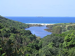
Glenrock Lagoon
| Glenrock Lagoon | |
|---|---|
 Looking east across Glenrock Lagoon from Leichhardt's Lookout on the Yuelarbah Track | |
| Location | Newcastle–Hunter, New South Wales, Australia |
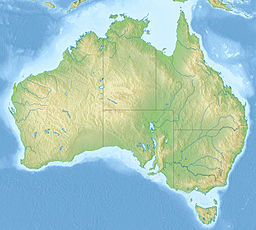
| Coordinates | 32°58′S 151°44′E / 32.967°S 151.733°E |
| Lake type | Intermediate fresh water small coastal creek[1] |
| Primary inflows | Flaggy Creek |
| Primary outflows | Tasman Sea, South Pacific Ocean |
| Catchment area | 7.4 square kilometres (2.9 sq mi)[2] |
| Basin countries | Australia |
| Surface area | 0.1 square kilometres (0.039 sq mi)[2] |
| Average depth | 0.3 metres (1 ft 0 in)[2] |
| Water volume | 15.1 megalitres (530×103 cu ft)[2] |
| Surface elevation | 0 m (0 ft) |
| Settlements | Adamstown, Dudley |
| Website | NSW Environment & Heritage webpage |
| References | [3] |
Glenrock Lagoon, an intermediate fresh water small coastal creek,[1] is located within the Lake Macquarie local government area in the Newcastle and Hunter regions of New South Wales, Australia. The lake is located near the Newcastle suburbs of Adamstown and Dudley and is situated about 153 kilometres (95 mi) north of Sydney.
- ^ a b Roy, P. S.; Williams, R. J.; Jones, A. R.; Yassini, I.; et al. (2001). "Structure and Function of South-east Australian Estuaries". Estuarine, Coastal and Shelf Science. 53: 351–384. doi:10.1006/ecss.2001.0796.
- ^ a b c d Cite error: The named reference
OEHwas invoked but never defined (see the help page). - ^ "Map of Glenrock State Conservation Area, NSW". Bonzle Digital Atlas of Australia. Archived from the original on 2 June 2023. Retrieved 21 March 2013.
Previous Page Next Page


