Our website is made possible by displaying online advertisements to our visitors.
Please consider supporting us by disabling your ad blocker.
Glooscap First Nation
Glooscap First Nation | |
|---|---|
 | |
| Motto(s): A community that is spirited and full of life | |
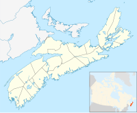
Location of Glooscap First Nation in Nova Scotia | |
| Coordinates: 45°02′25″N 64°13′45″W / 45.04028°N 64.22917°W | |
| Country | Canada |
| Province | Nova Scotia |
| County | Kings County |
| Established | 1907 |
| Government | |
| • Chief | Sidney Peters |
| • Council | Amanda Francis Gail Tupper Charlotte Warrington |
| • Member of Parliament | Kody Blois (L) |
| • Member of the Legislative Assembly | Julie Vanexan (PC) |
| Highest elevation | 100 m (300 ft) |
| Lowest elevation | 40 m (130 ft) |
| Population (2023) | |
• Total | 434 [1] |
| • Change 2013-23 | |
| Time zone | UTC-4 (Atlantic (AST)) |
| • Summer (DST) | UTC-3 (ADT) |
| NTS Map | 021H01 |
| Website | http://www.glooscapfirstnation.com/ |
| Postal code span: B0P1P0 | |
Glooscap First Nation is a Canadian Mi'kmaq aboriginal community located in both Kings County and Hants County, Nova Scotia. Also known as Kluskap, its reserve is located approximately 6.4 kilometres (4.0 mi) from the Town of Hantsport. Created in 1907 as Horton 35, the reserve encompasses some 171.1 hectares (423 acres) of rolling, mainly forested land. Forest management is practiced by the band.[2] There is a variety store, gas bar, Greco Pizza, and gaming centre. There is also a health centre, youth centre and chapel. The Glooscap Landing Business Park is also owned by Glooscap First Nation which houses a second gas bar and Tim Hortons.[3] The 2023 population was 434 people of whom approximately 100 lived on the reserve, making Glooscap the third-smallest First Nation community in Nova Scotia after Bear River First Nation and Annapolis Valley First Nation.[4] Glooscap's population grew by 41% in one decade between 2013 and 2023.[5]
- Reserves
- Glooscap 35
- Glooscap Landing Reserve[6]
- ^ "First Nation Profiles". Crown–Indigenous Relations and Northern Affairs Canada. Government of Canada. Retrieved 31 May 2024.
- ^ Mi'kmaq Resource Centre (UCCB), Mi'kmaw Bands in Nova Scotia[permanent dead link]
- ^ Aboriginal Canada Portal, Connectivity Survey Archived 2010-04-25 at the Wayback Machine
- ^ "Home". 3 November 2008.
- ^ Branch, Government of Canada; Indigenous and Northern Affairs Canada; Communications (2008-11-14). "First Nation Profiles". Crown–Indigenous Relations and Northern Affairs Canada. Government of Canada. Retrieved 2023-08-06.
{{cite web}}: CS1 maint: multiple names: authors list (link) - ^ "First Nation Profiles". Crown–Indigenous Relations and Northern Affairs Canada. Government of Canada. 14 November 2008.
Previous Page Next Page


