Our website is made possible by displaying online advertisements to our visitors.
Please consider supporting us by disabling your ad blocker.
Golden Highway
Golden Highway Mitchells Line of Road | |
|---|---|
 | |
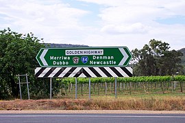
| Direction sign at end of Bylong Valley Way | |
| Coordinates | |
| General information | |
| Type | Highway |
| Length | 313 km (194 mi)[3] |
| Gazetted | August 1928 (as Main Road 62)[1] November 1996 (as State Highway 27)[2] |
| Route number(s) |
|
| Former route number | |
| Major junctions | |
| East end | Belford, New South Wales |
| West end | Dubbo, New South Wales |
| Location(s) | |
| Major settlements | Denman, Sandy Hollow, Merriwa, Dunedoo |
| Highway system | |
| ---- | |
Golden Highway (also known as Mitchells Line of Road at its eastern end) is a 313-kilometre (194 mi)[3] highway, located in the Hunter and Orana regions of New South Wales, Australia. It runs eastwards from Dubbo towards Newcastle on the coast, allowing road transport to avoid travelling over the Blue Mountains to Sydney, and is designated route B84.
- ^ "Main Roads Act, 1924-1927". Government Gazette of the State of New South Wales. No. 110. 17 August 1928. pp. 3814–20. Archived from the original on 3 August 2022. Retrieved 1 August 2022 – via National Library of Australia.
- ^ "Roads Act". Government Gazette of the State of New South Wales. No. 134. National Library of Australia. 22 November 1996. pp. 7657–62. Archived from the original on 13 October 2022. Retrieved 13 October 2022.
- ^ a b "Golden Highway" (Map). Google Maps. Retrieved 17 November 2016.
Previous Page Next Page


