Our website is made possible by displaying online advertisements to our visitors.
Please consider supporting us by disabling your ad blocker.
Goose Island (Chicago)
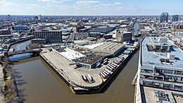
 Goose Island from the south | |
 Interactive map of Goose Island | |
| Geography | |
|---|---|
| Location | Chicago River |
| Coordinates | 41°54′16″N 87°39′15″W / 41.90444°N 87.65417°W |
| Area | 160 acres (65 ha) |
| Length | 1.5 mi (2.4 km) |
| Width | 0.5 mi (0.8 km) |
| Administration | |
United States | |
| State | Illinois |
| City | Chicago |
Goose Island is a 160-acre (65 ha) artificial island in Chicago, Illinois, formed by the North Branch of the Chicago River on the west and the North Branch Canal on the east. It is about 1.5 miles (2.4 km) long and 0.5 miles (0.80 km) across at its widest point.[1]
Previous Page Next Page


