Our website is made possible by displaying online advertisements to our visitors.
Please consider supporting us by disabling your ad blocker.
Grassy Island Range Lights
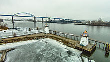
 The Grassy Island Range Lights as relocated (2014) | |
 | |
| Location | Grassy Island north of Green Bay, Wisconsin; relocated to Green Bay Yacht Club grounds |
|---|---|
| Coordinates | 44°33′37″N 87°59′35″W / 44.56028°N 87.99306°W[1] original; 44°32′10″N 88°00′19″W / 44.5362°N 88.0052°W[2] current |
| Tower | |
| Constructed | 1872[3] |
| Foundation | Pier |
| Construction | Wood with cedar shingles |
| Automated | 1934[3] |
| Shape | Pyramidal tower |
| Heritage | National Register of Historic Places listed place |
| Light | |
| Deactivated | 1966[3] |
| Focal height | 34 ft (10 m) (upper); 27 ft (8.2 m) (lower)[4] |
| Lens | Sixth Order Fresnel lens |
Grassy Island Range Lights | |
| NRHP reference No. | 04001484[5] |
| Added to NRHP | January 12, 2005 |
The Grassy Island Range Lights are a pair of lighthouses which were originally established to guide traffic through the channel into Green Bay harbor. They were deactivated and moved to shore as part of a channel-widening project.
- ^ Light List: Great Lakes: United States and Canada. Washington, DC: Government Printing Office. 1924. p. 230. Retrieved 2015-02-08.
- ^ Cite error: The named reference
LHFwas invoked but never defined (see the help page). - ^ a b c "Historic Light Station Information and Photography: Wisconsin". United States Coast Guard Historian's Office. Archived from the original on 2017-05-01.
- ^ Pepper, Terry. "Focal Heights". Retrieved 2015-02-08.
- ^ Cite error: The named reference
WHSwas invoked but never defined (see the help page).
Previous Page Next Page


