Our website is made possible by displaying online advertisements to our visitors.
Please consider supporting us by disabling your ad blocker.
Greenbelt (Golden Horseshoe)
| Ontario's Greenbelt | |
|---|---|
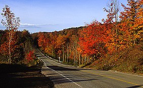
 Greenbelt - Lower Base Line Road, Toronto | |
 | |
| Location | Southern Ontario, Canada |
| Coordinates | 43°53′N 80°00′W / 43.88°N 80°W |
| Area | 2,000,000 acres (810,000 ha) |
| Established | 2005 |
| www | |
The Greenbelt is a protected area of green space, farmland, forests, wetlands, and watersheds, located in Southern Ontario, Canada. It surrounds a significant portion of the Golden Horseshoe.
Created by legislation passed by the Government of Ontario in 2005, the Greenbelt is considered a prevention of urban development and sprawl on environmentally sensitive land in the province. According to the Greenbelt Foundation, the Greenbelt includes 2,000,000 acres (810,000 ha) of land.[1] That includes 721,000 acres (292,000 ha) of protected wetlands, grasslands, and forests.[1]
- ^ a b "Green Belt". greenbelt.ca. Greenbelt Foundation. Retrieved 30 September 2021.
Previous Page Next Page


