Our website is made possible by displaying online advertisements to our visitors.
Please consider supporting us by disabling your ad blocker.
Gretna, Nebraska
Gretna, Nebraska | |
|---|---|
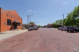
 Downtown looking south on McKenna Avenue, May 2017 | |
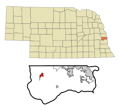
 Location of Gretna, Nebraska | |
| Coordinates: 41°08′27″N 96°14′23″W / 41.14083°N 96.23972°W | |
| Country | United States |
| State | Nebraska |
| County | Sarpy |
| Founded | Summer of 1886 |
| Incorporated | July 10, 1889 |
| Government | |
| • Mayor | Mike Evans |
| Area | |
• Total | 7.049 sq mi (18.257 km2) |
| • Land | 6.951 sq mi (18.003 km2) |
| • Water | 0.097 sq mi (0.251 km2) |
| Elevation | 1,112 ft (339 m) |
| Population | |
• Total | 5,083 |
• Estimate (2023)[4] | 9,054 |
| • Density | 1,302/sq mi (502.8/km2) |
| Time zone | UTC−6 (Central (CST)) |
| • Summer (DST) | UTC−5 (CDT) |
| ZIP Code | 68028 |
| Area code(s) | 402 and 531 |
| FIPS code | 31-20260 |
| GNIS feature ID | 2394248[2] |
| Sales tax | 7.5%[5] |
| Website | gretnane.org |
Gretna is a city in Sarpy County, Nebraska, United States. The population was 9,071 at the 2022 census.[6]
- ^ "2024 U.S. Gazetteer Files". United States Census Bureau. Retrieved September 9, 2024.
- ^ a b U.S. Geological Survey Geographic Names Information System: Gretna, Nebraska
- ^ Cite error: The named reference
2020 Census (City)was invoked but never defined (see the help page). - ^ Cite error: The named reference
USCensusEst2023was invoked but never defined (see the help page). - ^ "Gretna (NE) sales tax rate". Retrieved February 3, 2024.
- ^ Cite error: The named reference
:0was invoked but never defined (see the help page).
Previous Page Next Page


