Our website is made possible by displaying online advertisements to our visitors.
Please consider supporting us by disabling your ad blocker.
Greylingstad
This article needs additional citations for verification. (December 2009) |
Greylingstad | |
|---|---|
| Nthorwane | |
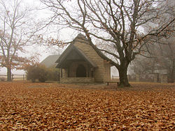
 Chapel of St Francis of Assisi, at the railway stop at Val just outside of Greylingstad. | |
| Coordinates: 26°45′S 28°45′E / 26.750°S 28.750°E | |
| Country | South Africa |
| Province | Mpumalanga |
| District | Gert Sibande |
| Municipality | Dipaleseng |
| Area | |
• Total | 9.33 km2 (3.60 sq mi) |
| Population (2011)[1] | |
• Total | 839 |
| • Density | 90/km2 (230/sq mi) |
| Racial makeup (2011) | |
| • Black African | 45.0% |
| • Coloured | 0.6% |
| • Indian/Asian | 0.8% |
| • White | 53.2% |
| • Other | 0.4% |
| First languages (2011) | |
| • Afrikaans | 51.7% |
| • Zulu | 27.9% |
| • Sotho | 6.6% |
| • English | 4.5% |
| • Other | 9.3% |
| Time zone | UTC+2 (SAST) |
| Postal code (street) | 2415 |
| PO box | 2415 |
| Area code | 017 |
Greylingstad (Afrikaans for Greyling City), officially Nthorwane,[2] is a small farming town west of Standerton in Mpumalanga, South Africa.
- ^ a b c d "Main Place Greylingstad". Census 2011.
- ^ "85 towns hit with name changes in South Africa – and more are on the way". BusinessTech. 14 April 2024. Retrieved 26 September 2024.
Previous Page Next Page


