Our website is made possible by displaying online advertisements to our visitors.
Please consider supporting us by disabling your ad blocker.
Gryfino County
Gryfino County
Powiat gryfiński | |
|---|---|
 Location within the voivodeship | |
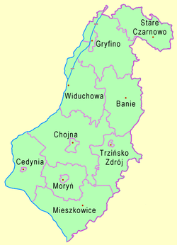
 Division into gminas | |
| Coordinates (Gryfino): 53°15′N 14°29′E / 53.250°N 14.483°E | |
| Country | |
| Voivodeship | West Pomeranian |
| Seat | Gryfino |
| Gminas | |
| Area | |
• Total | 1,869.54 km2 (721.83 sq mi) |
| Population (2006) | |
• Total | 82,813 |
| • Density | 44/km2 (110/sq mi) |
| • Urban | 37,937 |
| • Rural | 44,876 |
| Car plates | ZGR |
| Website | http://www.gryfino.powiat.pl/ |
Gryfino County (Polish: powiat gryfiński) is a unit of territorial administration and local government (powiat) in West Pomeranian Voivodeship, north-western Poland, on the German border. It came into being on January 1, 1999, as a result of the Polish local government reforms passed in 1998. Its administrative seat and largest town is Gryfino, which lies 20 kilometres (12 mi) south of the regional capital Szczecin. The county contains five other towns: Chojna, 32 km (20 mi) south of Gryfino, Mieszkowice, 52 km (32 mi) south of Gryfino, Trzcińsko-Zdrój, 33 km (21 mi) south of Gryfino, Cedynia, 45 km (28 mi) south-west of Gryfino, and Moryń, 44 km (27 mi) south of Gryfino.
The county covers an area of 1,869.54 square kilometres (721.8 sq mi). As of 2006 its total population is 82,813, out of which the population of Gryfino is 21,478, that of Chojna is 7,187, that of Mieszkowice is 3,553, that of Trzcińsko-Zdrój is 2,496, that of Cedynia is 1,653, that of Moryń is 1,570, and the rural population is 44,876.
Previous Page Next Page


