Our website is made possible by displaying online advertisements to our visitors.
Please consider supporting us by disabling your ad blocker.
Guadalcanal
Native name: Isatabu | |
|---|---|
 Guadalcanal Map | |
 | |
| Geography | |
| Location | Pacific Ocean |
| Coordinates | 09°35′24″S 160°14′06″E / 9.59000°S 160.23500°E |
| Archipelago | Solomon Islands |
| Area | 5,302 km2 (2,047 sq mi) |
| Highest elevation | 2,335 m (7661 ft) |
| Highest point | Mount Popomanaseu |
| Administration | |
| Province | Guadalcanal Province |
| Largest settlement | Honiara (pop. 92,344 (2021) |
| Demographics | |
| Population | 161,197 (2021) |
| Pop. density | 30.4/km2 (78.7/sq mi) |
| Ethnic groups |
|
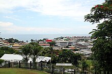
Guadalcanal (/ˌɡwɑːdəlkəˈnæl/; indigenous name: Isatabu) is the principal island in Guadalcanal Province of Solomon Islands, located in the southwestern Pacific Ocean, northeast of Australia. It is the largest island in the Solomons by area and the second-largest by population (after Malaita). The island is mainly covered in dense tropical rainforest and has a mountainous hinterland.


Guadalcanal was first charted by Europeans during the Spanish expedition of Álvaro de Mendaña in 1568. The name comes from the village of Guadalcanal, in the province of Seville, in Andalusia, Spain, birthplace of Pedro de Ortega Valencia, a member of Mendaña's expedition.
During 1942 and 1943, it was the scene of the Guadalcanal campaign and saw bitter fighting between Japanese and U.S. troops. The Americans were ultimately victorious. At the end of World War II, Honiara, on the north coast of Guadalcanal, became the new capital of the British Solomon Islands Protectorate and later the capital of the independent nation of Solomon Islands.
Previous Page Next Page


