Our website is made possible by displaying online advertisements to our visitors.
Please consider supporting us by disabling your ad blocker.
Hamburg Wadden Sea National Park
| Hamburg Wadden Sea National Park | |
|---|---|
| Nationalpark Hamburgisches Wattenmeer | |
 Satellite picture of the 3 islands of the national park | |
 | |
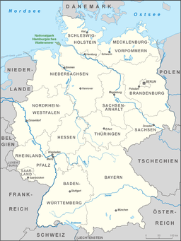
| Location | North Sea coast, Hamburg, |
| Coordinates | 53°56′07″N 8°28′22″E / 53.935329°N 8.472694°E |
| Area | 13,750 ha (53.1 sq mi) |
| Established | April 9, 1990 |
| Official name | Hamburgisches Wattenmeer |
| Designated | 1 August 1990 |
| Reference no. | 501[1] |

The Hamburg Wadden Sea National Park (German: Hamburgisches Wattenmeer) is the smallest of the three German Wadden Sea National Parks which protect the single ecological entity of the Wadden Sea reaching from Den Helder to Esbjerg.
It is an exclave of the city state of Hamburg in North Germany and lies 12.5 km off Cuxhaven in the estuary of the Elbe in the North Sea (German Bight) and includes the islands of Neuwerk, Scharhörn and Nigehörn. It is made up mainly of sand and mixed mudflats with shallow creeks, sand bars (Plaaten) and the dune islands. In 2011 the national park was added to the Wadden Sea World Heritage Site, highlighting its intact intertidal ecosystem, importance as a breeding area for many species of birds, and uniquely high biodiversity.[2]
- ^ "Hamburgisches Wattenmeer". Ramsar Sites Information Service. Retrieved 25 April 2018.
- ^ "Wadden Sea". UNESCO World Heritage Centre. United Nations Educational, Scientific, and Cultural Organization. Retrieved 26 June 2021.
Previous Page Next Page
Taman Nasional Segara Wadden Hamburg BAN Nationalpark Hamburgisches Wattenmeer Danish Nationalpark Hamburgisches Wattenmeer German Parque nacional del mar de Frisia hamburgués Spanish Wadden itsasoko Parke Nazionala (Hanburgo) EU هامبورگ وادن زا ناتسیونال پارک FA Parc national de la mer des Wadden de Hambourg French Parco nazionale del Wattenmeer di Amburgo Italian ჰამბურგის ვადენზეეს ეროვნული პარკი KA Национален парк Ваденско Море (Хамбург) MK


