Our website is made possible by displaying online advertisements to our visitors.
Please consider supporting us by disabling your ad blocker.
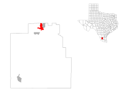
Hebbronville, Texas
Hebbronville, Texas | |
|---|---|
 Water tower in Hebbronville | |
 | |
| Coordinates: 27°18′41″N 98°40′52″W / 27.31139°N 98.68111°W | |
| Country | United States |
| State | Texas |
| County | Jim Hogg |
| Area | |
• Total | 6.3 sq mi (16.2 km2) |
| • Land | 6.3 sq mi (16.2 km2) |
| • Water | 0.0 sq mi (0.0 km2) |
| Elevation | 548 ft (167 m) |
| Population (2020) | |
• Total | 4,101 |
| • Density | 660/sq mi (250/km2) |
| Time zone | UTC−6 (Central (CST)) |
| • Summer (DST) | UTC−5 (CDT) |
| ZIP code | 78361 |
| Area code | 361 |
| FIPS code | 48-33008[2] |
| GNIS feature ID | 1337545[1] |
Hebbronville (/ˈhɛbrənvɪl/ HEB-rən-vil) is a census-designated place (CDP) in and the county seat of Jim Hogg County, Texas, United States.[3] The population was 4,101 at the 2020 census.[4]
The Colegio Altamirano, founded by settlers of Spanish ancestry who wanted their children to learn Spanish culture, was an institution in Hebbronville from 1897 until its closing in 1958.
- ^ a b U.S. Geological Survey Geographic Names Information System: Hebbronville, Texas
- ^ "U.S. Census website". United States Census Bureau. Retrieved January 31, 2008.
- ^ "Find a County". National Association of Counties. Retrieved June 7, 2011.
- ^ Cite error: The named reference
2020CensusP2was invoked but never defined (see the help page).
Previous Page Next Page


