Our website is made possible by displaying online advertisements to our visitors.
Please consider supporting us by disabling your ad blocker.
Heishui County
Heishui County
黑水县 • ཁྲོ་ཆུ་རྫོང་། • Vvlukvua Choqu | |
|---|---|
 | |
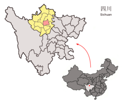
 Location of Heishui County (light red) in Aba (yellow) and Sichuan (light gray) | |
| Coordinates: 32°14′07″N 103°03′20″E / 32.23528°N 103.05556°E | |
| Country | China |
| Province | Sichuan |
| Autonomous prefecture | Ngawa |
| County seat | Doka (Luhua) |
| Area | |
• Total | 4,356 km2 (1,682 sq mi) |
| Elevation | 3,544 m (11,627 ft) |
| Population (2020)[2] | |
• Total | 44,564 |
| • Density | 10/km2 (26/sq mi) |
| Time zone | UTC+8 (China Standard) |
| Website | www |
| Heishui County | |||||||
|---|---|---|---|---|---|---|---|
| Chinese name | |||||||
| Simplified Chinese | 黑水县 | ||||||
| Traditional Chinese | 黑水縣 | ||||||
| Literal meaning | black water | ||||||
| |||||||
| Tibetan name | |||||||
| Tibetan | ཁྲོ་ཆུ་རྫོང་། | ||||||
| |||||||
| Qiang name | |||||||
| Qiang | Vvlukvua | ||||||
Heishui County (Chinese: 黑水县; Tibetan: ཁྲོ་ཆུ་རྫོང་།; Qiang: Vvlukvua) is a county in the north of Sichuan Province, China. It is under the administration of the Ngawa Tibetan and Qiang Autonomous Prefecture.[3] The county has an area of 1,682 square miles (4,356 km2) and its average elevation is 11,627 feet (3,544 m).[1] As of 2016, the county has a population of 61,744.[4]
- ^ a b c Li, Xiguang (2003-01-10). "Prologue". 找故事的艺术——在长征路上体味清华新闻学 [The Art of Storytelling: Experience Tsinghua News on the Long March] (in Chinese). Tsinghua University Press (published 2003-01-01). p. 18. ISBN 9787302062165. Archived from the original on 2017-08-12. Retrieved 2017-08-11.
- ^ "阿坝州第七次全国人口普查公报第二号——县(市)人口情况" (in Chinese). Government of Ngawa Prefecture. 2021-06-11. Archived from the original on December 2, 2024.
- ^ 2016年统计用区划代码 [Statistical zoning code, 2016 (Ngawa Tibetan and Qiang Autonomous Prefecture)]. National Bureau of Statistics of the People's Republic of China (in Chinese). National Bureau of Statistics of the People's Republic of China. 2016. Archived from the original on 2017-08-12. Retrieved 2017-08-11.
- ^ Han, Fei; Li, Yaqiong, eds. (2016-03-10). 黑水县情 [Heishui County Overview]. Heishui County Portal (in Chinese). Heishui County Government. Archived from the original on 2017-08-12. Retrieved 2017-08-11.
Previous Page Next Page


