Our website is made possible by displaying online advertisements to our visitors.
Please consider supporting us by disabling your ad blocker.
Hermannskogel
| Hermannskogel | |
|---|---|
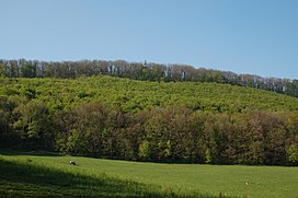
 Hermannskogel (and top of Habsburgwarte) seen from the Rohrerwiese | |
| Highest point | |
| Elevation | 542 m (1,778 ft) |
| Coordinates | 48°16′N 16°17′E / 48.267°N 16.283°E |
| Geography | |
The Hermannskogel (German pronunciation: [ˈhɛʁmansˌkoːɡl̩] ⓘ) is a hill in Döbling, the 19th district of Vienna. At 542 metres above sea level, it is the highest natural point of Vienna. It lies on the border to Lower Austria.
The Habsburgwarte, standing atop the Hermannskogel, marked the kilometre zero in cartographic measurements used in Austria-Hungary until 1918.
Previous Page Next Page


