Our website is made possible by displaying online advertisements to our visitors.
Please consider supporting us by disabling your ad blocker.
Hida Province
| Hida Province 飛騨国 | |
|---|---|
| pre-Meiji period Japan | |
| 701–1871 | |
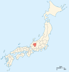
 Map of Japanese provinces (1868) with Hida Province highlighted | |
| Capital | Takayama |
| Area | |
| • Coordinates | 36°30′N 135°45′E / 36.500°N 135.750°E |
| History | |
• Ritsuryō system | 701 |
• Disestablished | 1871 |
| Today part of | Gifu Prefecture |

Hida Province (飛騨国, Hida-no-kuni) was a province of Japan in the area that is today the northern portion of Gifu Prefecture in the Chūbu region of Japan.[1] Hida bordered on Echizen, Mino, Shinano, Etchū, and Kaga Provinces. It was part of Tōsandō Circuit. Its abbreviated name was Hishū (飛州). Under the Engishiki classification system, Hida was ranked as an "inferior country" (下国) and a middle country (中国) in terms of its importance and distance from the capital. Currently, the entire area of the former Hida Province consists of the cities of Hida, Takayama and most of the city of Gero, and the village of Shirakawa, in Ōno District .
- ^ Nussbaum, Louis-Frédéric. (2005). "Wakasa" in Japan Encyclopedia, 307, p. 307, at Google Books.
Previous Page Next Page


