Our website is made possible by displaying online advertisements to our visitors.
Please consider supporting us by disabling your ad blocker.
Huntington Park, California
Huntington Park, California | |
|---|---|
 Pacific Boulevard and Clarendon Avenue, 2009 | |
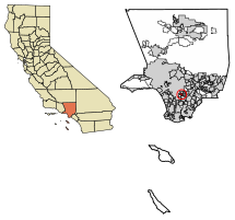
 Location of Huntington Park in Los Angeles County, California. | |
| Coordinates: 33°59′N 118°13′W / 33.983°N 118.217°W | |
| Country | |
| State | |
| County | Los Angeles |
| Incorporated | September 1, 1906[1] |
| Government | |
| • Type | Council–manager[2] |
| • Mayor | Karina Macias[2] |
| • Vice Mayor | Arturo Flores |
| Area | |
• Total | 3.02 sq mi (7.81 km2) |
| • Land | 3.01 sq mi (7.80 km2) |
| • Water | 0.00 sq mi (0.01 km2) 0.11% |
| Elevation | 171 ft (52 m) |
| Population | |
• Total | 54,883 |
• Estimate (2022)[5] | 52,633 |
| • Density | 18,000/sq mi (7,000/km2) |
| Time zone | UTC−8 (Pacific) |
| • Summer (DST) | UTC−7 (PDT) |
| ZIP Code | 90255[6] |
| Area code | 323[7] |
| FIPS code | 06-36056 |
| GNIS feature IDs | 1660778, 2410079 |
| Website | www |
Huntington Park is a city located in the South Central region of Los Angeles County, California, United States. The area includes the separate communities of Florence, Firestone Park, Graham, and Walnut Park, California. As of the 2020 census, the city had a total population of 54,883, of whom 97% are Hispanic/Latino and about half were born outside the U.S.[5][8]
Huntington Park and its Pacific Boulevard area is a mostly Hispanic, working-class inner Southeast L.A. area.
- ^ "California Cities by Incorporation Date". California Association of Local Agency Formation Commissions. Archived from the original (Word) on November 3, 2014. Retrieved August 25, 2014.
- ^ a b "Huntington Park! - City Council". Retrieved December 1, 2020.
- ^ "2019 U.S. Gazetteer Files". United States Census Bureau. Retrieved July 1, 2020.
- ^ "Huntington Park". Geographic Names Information System. United States Geological Survey, United States Department of the Interior. Retrieved January 22, 2015.
- ^ a b c "Huntington Park (city) QuickFacts". United States Census Bureau. Archived from the original on April 15, 2023. Retrieved January 18, 2024.
- ^ "USPS - ZIP Code Lookup - Find a ZIP+ 4 Code By City Results". Retrieved January 18, 2007.
- ^ "Number Administration System - NPA and City/Town Search Results". Archived from the original on September 26, 2007. Retrieved January 18, 2007.
- ^ Rojas, Leslie Berestein (August 17, 2005). "As Huntington Park Goes, So Southern California". KCET.
Previous Page Next Page


