Our website is made possible by displaying online advertisements to our visitors.
Please consider supporting us by disabling your ad blocker.
Hurricane Darby (2004)
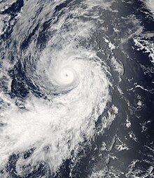
 Hurricane Darby intensifying in the open Pacific Ocean on July 28 | |
| Meteorological history | |
|---|---|
| Formed | July 26, 2004 |
| Dissipated | August 1, 2004 |
| Category 3 major hurricane | |
| 1-minute sustained (SSHWS/NWS) | |
| Highest winds | 120 mph (195 km/h) |
| Lowest pressure | 957 mbar (hPa); 28.26 inHg |
| Overall effects | |
| Fatalities | None reported |
| Areas affected | Southwestern Hawaii |
| IBTrACS | |
Part of the 2004 Pacific hurricane season | |
Hurricane Darby was the first Eastern Pacific major hurricane since Hurricane Kenna in 2002. The sixth tropical cyclone, fourth named storm, and second hurricane of the 2004 Pacific hurricane season, Darby developed from a tropical wave that emerged from the west coast of Africa on July 12. After crossing into the Eastern Pacific, the storm became a tropical depression on June 26. The system steadily intensified, and became a hurricane on 000 UTC July 28. Darby peaked as a Category 3 hurricane on the Saffir-Simpson Hurricane Scale, though it quickly deteriorated due to cooler waters and increasing wind shear. While Darby dissipated on August 1, the remnants of the tropical cyclone affected the Hawaiian Islands. The system produced high waves and heavy rainfall that led to extensive flash flooding. Numerous roads were closed, while minor landslides and rockslides were reported. Despite the effects, no fatalities or severe damages occurred.
Previous Page Next Page


