Our website is made possible by displaying online advertisements to our visitors.
Please consider supporting us by disabling your ad blocker.
Idabel, Oklahoma
Idabel, Oklahoma
Bokhoma (Choctaw) | |
|---|---|
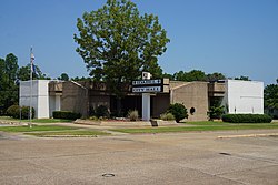
 Idabel City Hall | |
| Nickname: Dogwood Capital of Oklahoma | |
 Location of Idabel, Oklahoma | |
| Coordinates: 33°53′44″N 94°49′35″W / 33.89556°N 94.82639°W[1] | |
| Country | United States |
| State | Oklahoma |
| County | McCurtain |
| Government | |
| • Type | Mayor-council |
| Area | |
• Total | 16.75 sq mi (43.38 km2) |
| • Land | 16.63 sq mi (43.08 km2) |
| • Water | 0.12 sq mi (0.30 km2) |
| Elevation | 463 ft (141 m) |
| Population (2020) | |
• Total | 6,961 |
| • Density | 418.51/sq mi (161.58/km2) |
| Time zone | UTC-6 (Central (CST)) |
| • Summer (DST) | UTC-5 (CDT) |
| ZIP code | 74745 |
| Area code | 580 |
| FIPS code | 40-36750 [3] |
| GNIS feature ID | 2410089[1] |
| Website | www |
Idabel is a city in and the county seat of McCurtain County, Oklahoma, United States. The population was 7,010 at the 2010 census.[4] It is in Oklahoma's southeast corner, a tourist area known as Choctaw Country.
- ^ a b c U.S. Geological Survey Geographic Names Information System: Idabel, Oklahoma
- ^ "ArcGIS REST Services Directory". United States Census Bureau. Retrieved September 20, 2022.
- ^ "U.S. Census website". United States Census Bureau. Retrieved January 31, 2008.
- ^ "Find a County". National Association of Counties. Archived from the original on May 31, 2011. Retrieved June 7, 2011.
Previous Page Next Page


