Our website is made possible by displaying online advertisements to our visitors.
Please consider supporting us by disabling your ad blocker.
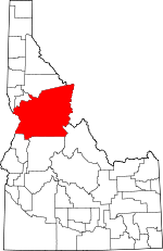
Idaho County, Idaho
Idaho County | |
|---|---|
 | |
 Location within the U.S. state of Idaho | |
 Idaho's location within the U.S. | |
| Coordinates: 45°51′N 115°28′W / 45.85°N 115.46°W | |
| Country | |
| State | |
| Founded | December 20, 1861 |
| Named for | Idaho |
| Seat | Grangeville |
| Largest city | Grangeville |
| Area | |
• Total | 8,503 sq mi (22,020 km2) |
| • Land | 8,477 sq mi (21,960 km2) |
| • Water | 26 sq mi (70 km2) 0.3% |
| Population (2020) | |
• Total | 16,541 |
• Estimate (2023) | 17,890 |
| • Density | 1.9/sq mi (0.75/km2) |
| Time zones | |
| North of Salmon River | UTC−8 (Pacific) |
| • Summer (DST) | UTC−7 (PDT) |
| South of Salmon River | UTC−7 (Mountain) |
| • Summer (DST) | UTC−6 (MDT) |
| Congressional district | 1st |
| Website | idahocounty |
Idaho County is a county in the U.S. state of Idaho, and the largest by area in the state. As of the 2020 census, the population was 16,541. The county seat is Grangeville.[1] Previous county seats of the area were Florence (1864–68), Washington (1868–75), and Mount Idaho (1875–1902).[2]
- ^ "Find a County". National Association of Counties. Archived from the original on May 31, 2011. Retrieved June 7, 2011.
- ^ "SITE REPORT - WARRENS" (PDF). Idaho State Historical Society. Archived from the original (PDF) on February 9, 2017. Retrieved February 19, 2017.
Previous Page Next Page


