Our website is made possible by displaying online advertisements to our visitors.
Please consider supporting us by disabling your ad blocker.
Indiana County, Pennsylvania
Indiana County | |
|---|---|
 Indiana County Courthouse | |
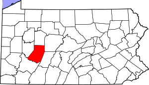
 Location within the U.S. state of Pennsylvania | |
 Pennsylvania's location within the U.S. | |
| Coordinates: 40°39′N 79°05′W / 40.65°N 79.09°W | |
| Country | |
| State | |
| Founded | November 3, 1806 |
| Seat | Indiana |
| Largest borough | Indiana |
| Area | |
• Total | 834 sq mi (2,160 km2) |
| • Land | 827 sq mi (2,140 km2) |
| • Water | 7.3 sq mi (19 km2) 0.9% |
| Population (2020) | |
• Total | 83,246 |
| • Density | 101/sq mi (39/km2) |
| Time zone | UTC−5 (Eastern) |
| • Summer (DST) | UTC−4 (EDT) |
| Congressional district | 15th |
| Website | www |
Indiana County is a county in the Commonwealth of Pennsylvania. It is located in the west central part of Pennsylvania. As of the 2020 census, the population was 83,246.[1] Its county seat is Indiana.[2] Indiana County comprises the Indiana, PA Micropolitan Statistical Area, which is also included in the Pittsburgh-New Castle-Weirton, PA-WV-OH Combined Statistical Area. The county is part of the Southwest Pennsylvania region of the state.[a]
Prior to the Revolutionary War, some settlers proposed this as part of a larger, separate colony to be known as Vandalia, but opposing interests and the war intervened. Afterward, claims to the territory by both the states of Virginia and Pennsylvania had to be reconciled. After this land was assigned to Pennsylvania by the federal government according to the placement of the Mason–Dixon line, Indiana County was created on March 30, 1803, from parts of Westmoreland and Clearfield counties and was formally organized in 1806.[3]
- ^ "Census - Geography Profile: Indiana County, Pennsylvania". United States Census Bureau. Retrieved December 18, 2022.
- ^ "Find a County". National Association of Counties. Archived from the original on May 31, 2011. Retrieved June 7, 2011.
- ^ "Pennsylvania: Individual County Chronologies". Pennsylvania Atlas of Historical County Boundaries. The Newberry Library. 2008. Archived from the original on March 25, 2015. Retrieved March 12, 2015.
Cite error: There are <ref group=lower-alpha> tags or {{efn}} templates on this page, but the references will not show without a {{reflist|group=lower-alpha}} template or {{notelist}} template (see the help page).
Previous Page Next Page
مقاطعة إنديانا (بنسيلفانيا) Arabic Indiana County, Pennsylvania BAR Индиана (окръг, Пенсилвания) Bulgarian ইন্ডিয়ানা কাউন্টি, পেনসিলভানিয়া BPY Indiana Gông (Pennsylvania) CDO Indiana County CEB Indiana County, Pennsylvania CY Indiana County German Κομητεία Ιντιάνα (Πενσυλβάνια) Greek Kantono Indiana EO


