Our website is made possible by displaying online advertisements to our visitors.
Please consider supporting us by disabling your ad blocker.
Ionia County, Michigan
Ionia County | |
|---|---|
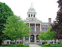
 Ionia County Courthouse in Ionia | |
 Location within the U.S. state of Michigan | |
 Michigan's location within the U.S. | |
| Coordinates: 42°56′N 85°04′W / 42.94°N 85.07°W | |
| Country | |
| State | |
| Founded | March 2, 1831 (created) 1837 (organized)[1] |
| Named for | Ionia |
| Seat | Ionia |
| Largest city | Ionia |
| Area | |
• Total | 580 sq mi (1,500 km2) |
| • Land | 571 sq mi (1,480 km2) |
| • Water | 8.7 sq mi (23 km2) 1.5% |
| Population (2020) | |
• Total | 66,804 |
| • Density | 112/sq mi (43/km2) |
| Time zone | UTC−5 (Eastern) |
| • Summer (DST) | UTC−4 (EDT) |
| Congressional district | 2nd |
| Website | ioniacounty |
Ionia County (/aɪˈoʊnjə/ eye-OH-nyə) is a county located in the U.S. state of Michigan. As of the 2020 census, the population was 66,804.[2] The county seat is Ionia.[3] The Ionia County Courthouse was designed by Claire Allen, a prominent southern Michigan architect.
Ionia County is part of the Grand Rapids-Kentwood metropolitan statistical area.
- ^ "Ionia County". Clarke Historical Library, Central Michigan University. Archived from the original on September 6, 2015. Retrieved January 19, 2013.
- ^ "QuickFacts: Ionia County, Michigan". US Census Bureau. Archived from the original on February 13, 2023. Retrieved September 15, 2021.
- ^ "Find a County". National Association of Counties. Archived from the original on May 31, 2011. Retrieved June 7, 2011.
Previous Page Next Page


