Our website is made possible by displaying online advertisements to our visitors.
Please consider supporting us by disabling your ad blocker.
Ivanovo Municipality
Ivanovo Municipality
Община Иваново | |
|---|---|
Municipality | |
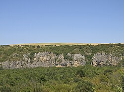
 Rocks in Rusenski Lom Nature Park | |
 Ivanovo Municipality within Bulgaria and Ruse Province. | |
| Coordinates: 43°41′N 25°57′E / 43.683°N 25.950°E | |
| Country | |
| Province (Oblast) | Ruse |
| Admin. centre (Obshtinski tsentar) | Ivanovo |
| Area | |
• Total | 495.45 km2 (191.29 sq mi) |
| Population (December 2009)[1] | |
• Total | 10,339 |
| • Density | 21/km2 (54/sq mi) |
| Time zone | UTC+2 (EET) |
| • Summer (DST) | UTC+3 (EEST) |
Ivanovo Municipality (Bulgarian: Община Иваново) is a municipality (obshtina) in Ruse Province, Central-North Bulgaria, located along the right bank of Danube river in the Danubian Plain. It is named after its administrative centre - the village of Ivanovo.
The municipality covers a territory of 495.45 km2 (191.29 sq mi) with a population of 10,339 inhabitants, as of December 2009.[1]
The area is best known with the Rock-hewn Churches of Ivanovo which is an UNESCO World Heritage Site. Other important sights in the municipality include the medieval Bulgarian fortress of Cherven, which reached its apogee in the 13th and 14th centuries and features a well-preserved keep from the 14th century, and the Rusenski Lom Nature Park.
The population is predominantly Bulgarian (83.5%), with Turkish (9.4%), Romani (5.9%) and other minorities (1.2%, mostly Tatars in the village of Trastenik).[2]
The main road E85 crosses the area from south to north, connecting the province centre of Ruse with the cities of Veliko Tarnovo and respectively Pleven and Sofia.
- ^ a b (in English) Bulgarian National Statistical Institute - Bulgarian provinces and municipalities in 2009 Archived 2010-11-13 at the Wayback Machine
- ^ (in Bulgarian) Ivanovo official web site
Previous Page Next Page


