Our website is made possible by displaying online advertisements to our visitors.
Please consider supporting us by disabling your ad blocker.
Ixopo
Ixopo
Stuartstown | |
|---|---|
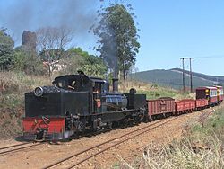
 SAR Class NG G11 no. NG55 arriving at Ixopo station | |
| Coordinates: 30°09′26″S 30°03′53″E / 30.15722°S 30.06472°E | |
| Country | South Africa |
| Province | KwaZulu-Natal |
| District | Harry Gwala |
| Municipality | Ubuhlebezwe |
| Area | |
• Total | 10.85 km2 (4.19 sq mi) |
| Population (2011)[1] | |
• Total | 12,461 |
| • Density | 1,100/km2 (3,000/sq mi) |
| Racial makeup (2011) | |
| • Black African | 90.6% |
| • Coloured | 5.6% |
| • Indian/Asian | 1.9% |
| • White | 1.4% |
| • Other | 0.5% |
| First languages (2011) | |
| • Zulu | 74.8% |
| • English | 10.6% |
| • Xhosa | 7.6% |
| • Sotho | 2.2% |
| • Other | 4.8% |
| Time zone | UTC+2 (SAST) |
| Postal code (street) | 3276 |
| PO box | 3276 |
| Area code | 039 |
Ixopo, also known as Stuartstown, is a town situated on a tributary of the uMkhomazi River along the R56 highway in the midlands of KwaZulu-Natal, South Africa.
- ^ a b c d "Main Place Ixopo". Census 2011.
Previous Page Next Page


