Our website is made possible by displaying online advertisements to our visitors.
Please consider supporting us by disabling your ad blocker.
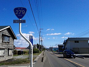
Japan National Route 279
| National Route 279 | ||||
|---|---|---|---|---|
| 国道279号 | ||||
Japan National Route 279 highlighted in red | ||||
 | ||||
| Route information | ||||
| Length | 134.0 km[1] (83.3 mi) | |||
| Existed | 1970–present | |||
| Major junctions | ||||
| North end | in Hakodate, Hokkaido | |||
| ||||
| South end | in Noheji, Aomori | |||
| Location | ||||
| Country | Japan | |||
| Highway system | ||||
| ||||
National Route 279 (国道279号, Kokudō Nihyaku nana-jukyūgō) is a national highway of Japan that traverses the prefectures of Aomori and Hokkaido, as well as the Tsugaru Strait that separates them. The 134.0-kilometer (83.3 mi) highway begins at an intersection with National Route 5 in Hakodate, then crosses the Tsugaru Strait on a ferry from Hakodate to Ōma, Aomori, that it shares with National Route 279, where it then travels south through eastern Aomori Prefecture, passing through the city of Mutsu before ending at an intersection with National Route 4 in Noheji.
National Route 279's path across Aomori follows one of the oldest roads in northern Japan, a pilgrimage path called the Tanabu Kaidō (田名部街道) to Mount Osore, a caldera believed in Japanese mythology to be a gate to the underworld.
- ^ "一般国道の路線別、都道府県別道路現況" [Road statistics by General National Highway route and prefecture] (PDF) (in Japanese). Ministry of Land, Infrastructure, Transport and Tourism. Retrieved 10 October 2019.
Previous Page Next Page


