Our website is made possible by displaying online advertisements to our visitors.
Please consider supporting us by disabling your ad blocker.
Johnston County, North Carolina
Johnston County | |
|---|---|
 | |
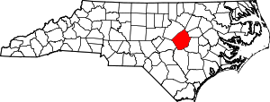
 Location within the U.S. state of North Carolina | |
 North Carolina's location within the U.S. | |
| Coordinates: 35°31′N 78°22′W / 35.51°N 78.37°W | |
| Country | |
| State | |
| Established | June 28, 1746 |
| Named for | Gabriel Johnston |
| Seat | Smithfield |
| Largest community | Clayton |
| Area | |
• Total | 795.65 sq mi (2,060.7 km2) |
| • Land | 792.02 sq mi (2,051.3 km2) |
| • Water | 3.63 sq mi (9.4 km2) 0.46% |
| Population (2020) | |
• Total | 215,999 |
• Estimate (2023) | 241,955 |
| • Density | 272.72/sq mi (105.30/km2) |
| Time zone | UTC−5 (Eastern) |
| • Summer (DST) | UTC−4 (EDT) |
| ZIP Codes | 27501, 27504, 27520, 27524, 27527, 27529, 27542, 27555, 27557, 27568, 27569, 27576, 27577, 27591, 27592, 27597, 27603, 28334, 28366 |
| Area code | 919, 984 |
| Congressional district | 13th |
| Website | johnstonnc |
Johnston County is a county located in the U.S. state of North Carolina. As of the 2020 census, the population was 215,999.[1] Its county seat is Smithfield.[2]
Johnston County is included in the Raleigh-Cary, NC Metropolitan Statistical Area, which is also included in the Raleigh-Durham-Cary, NC Combined Statistical Area, which had an estimated population of 2,368,947 in 2023.[3]
- ^ Cite error: The named reference
2020CensusQuickFactswas invoked but never defined (see the help page). - ^ "Find a County". National Association of Counties. Archived from the original on May 31, 2011. Retrieved June 7, 2011.
- ^ "Metropolitan and Micropolitan Statistical Areas Population Totals: 2020-2023". United States Census Bureau, Population Division. March 14, 2024. Retrieved March 15, 2024.
Previous Page Next Page
Johnston County, Noord-Carolina AF مقاطعة جونستون (كارولاينا الشمالية) Arabic Johnston County, North Carolina BAR Джонстън (окръг, Северна Каролина) Bulgarian জোন্সটোন কাউন্টি, নর্থ ক্যারোলাইনা BPY Johnston Gông (North Carolina) CDO Джонстон (гуо, Къилбаседа Каролина) CE Johnston County (kondado sa Tinipong Bansa, North Carolina) CEB Johnston County, Gogledd Carolina CY Johnston County (North Carolina) German


