Our website is made possible by displaying online advertisements to our visitors.
Please consider supporting us by disabling your ad blocker.
Kalmit
| Kalmit | |
|---|---|
 The Kalmit | |
| Highest point | |
| Elevation | 672.6 m above sea level (NN) (2,207 ft) |
| Listing | Highest peak in the Palatine Forest |
| Coordinates | 49°19′08″N 8°04′58″E / 49.31889°N 8.08278°E |
| Geography | |
| Parent range | Haardt |
| Geology | |
| Mountain type | Bunter Sandstone |
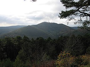
The Kalmit is the highest peak in the Palatinate Forest and the second highest (after the Donnersberg) in the Palatinate region of Germany. It is 672.6 m above sea level (NHN)[1] and located 5.5 kilometres (3.4 mi) south of the town of Neustadt an der Weinstraße.
The mountain attracts many tourists thanks to the numerous footpaths leading to its summit, its mountaintop restaurant, extensive views over the Palatinate wine region and striking rock formations on its forest-clad mountainsides.[citation needed]
Previous Page Next Page


