Our website is made possible by displaying online advertisements to our visitors.
Please consider supporting us by disabling your ad blocker.
Kangaroo Island
 View of the south west of the island | |
 | |
| Geography | |
|---|---|
| Location | Great Australian Bight |
| Coordinates | 35°50′S 137°15′E / 35.833°S 137.250°E |
| Area | 4,405 km2 (1,701 sq mi) |
| Length | 145 km (90.1 mi) |
| Width | 0.9–54 km (0.56–33.55 mi) |
| Coastline | 540 km (336 mi) |
| Highest elevation | 307 m (1007 ft) |
| Administration | |
Australia | |
| State | South Australia |
| LGA | Kangaroo Island Council |
| Largest settlement | Kingscote (pop. 1962[1]) |
| Demographics | |
| Population | 4,894 (2021) |
| Pop. density | 1.07/km2 (2.77/sq mi) |
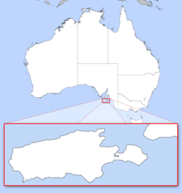
Kangaroo Island (Kaurna: Karta Pintingga, lit. '[The] Island of the Dead' in the language of the Kaurna people')[2] is Australia's third-largest island, after Tasmania and Melville Island. It lies in the state of South Australia, 112 km (70 mi) southwest of Adelaide. Its closest point to the mainland is Snapper Point in Backstairs Passage, which is 13.5 km (8.4 mi) from the Fleurieu Peninsula.
The native population of Aboriginal Australians that once occupied the island (sometimes referred to as the Kartan people) disappeared from the archaeological record sometime after the land became an island[3] following the rising sea levels associated with the Last Glacial Period around 10,000 years ago. It was subsequently settled intermittently by sealers and whalers in the early 19th century, and from 1836 on a permanent basis during the British colonisation of South Australia.
Since then the island's economy has been principally agricultural, with a southern rock lobster fishery and with tourism growing in importance. The largest town, and the administrative centre, is Kingscote. The island has several nature reserves to protect the remnants of its natural vegetation and native animals, with the largest and best-known being Flinders Chase National Park at the western end.
- ^ Australian Bureau of Statistics (28 June 2022). "Kingscote". 2021 Census QuickStats. Retrieved 9 September 2022.
- ^ Cite error: The named reference
:1was invoked but never defined (see the help page). - ^ Walshe, Keryn (2005). "Indigenous Archaeological Sites and the Black Swamp Fossil Bed: Rocky River Precinct, Flinders Chase National Park, Kangaroo Island, South Australia". Australian Archaeology. 60 (1): 61–64. doi:10.1080/03122417.2005.11681808. ISSN 0312-2417. S2CID 143379553. Archived from the original on 24 February 2024. Retrieved 15 August 2022.
Previous Page Next Page


