Our website is made possible by displaying online advertisements to our visitors.
Please consider supporting us by disabling your ad blocker.
Kapisa Province
Kapisa
کاپیسا | |
|---|---|
 A road in the Tagab District of Kapisa Province | |
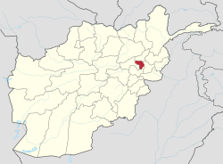
 Map of Afghanistan with Kapisa highlighted | |
| Coordinates (Capital): 35°00′N 69°42′E / 35.0°N 69.7°E | |
| Country | |
| Capital | Mahmud-i-Raqi |
| Government | |
| • Governor | Mohammadullah Idris |
| • Deputy Governor | Maulvi Asadullah Sanan[1] |
| Area | |
• Total | 1,842.1 km2 (711.2 sq mi) |
| Population (2024)[2] | |
• Total | 523,201 |
| • Density | 280/km2 (740/sq mi) |
| Time zone | UTC+4:30 (Afghanistan Time) |
| Postal code | 12xx |
| ISO 3166 code | AF-KAP |
| Main languages | Dari Pashto |
Kapisa (/kəˈpiːsə/ kə-PEE-sə; Dari and Pashto: کاپيسا Kāpisā) is the smallest of Afghanistan's thirty-four provinces and is located in the north-east of the country. It has an estimated population of 523,201 people[3] and an area of 1,842 km2 (711 sq mi), making it the most densely populated province apart from Kabul Province.[4] It borders Panjshir Province to the north, Laghman Province to the east, Kabul Province to the south and Parwan Province to the west. Mahmud-i-Raqi is the provincial capital, while the most populous city and district of Kapisa is Nijrab.
- ^ "په کاپیسا ولایت کې له واش پروژې څخه د افغاني سرې میاشتې ټولنې د رئیس لیدنه! | ARCS". arcs.af.
- ^ {{cite web |url=https://drive.google.com/file/d/1PWzeE5zCoqwHfht-16xVkHejlgW9Wbeb/view
- ^ "براورد نفوس کشور سال 1403.pdf". Google Docs. Retrieved 2025-01-04.
- ^ "Afghanistan Provinces". Statoids.com. Retrieved 2013-05-02.
Previous Page Next Page


